Two growing storms could bring major trouble to the Atlantic coast
A perilous and complex weather dance is unfolding in the central Atlantic, a brewing cauldron of atmospheric instability that forecasters are calling an "utter mess." Two developing tropical systems—one now Tropical Storm Humberto—are on a potential collision course, threatening a rare and chaotic interaction that has sent uncertainty skyrocketing for the U.S. East Coast.

Twin Threats: Humberto Forms, Another Looms
Deceptive calm of the early hurricane season has shattered. The NOAA National Hurricane Center has officially upgraded the easternmost disturbance, formerly Invest 93L, to Tropical Storm Humberto. Hot on its heels is Invest 94L, a sprawling area of thunderstorms that could soon become Tropical Storm Imelda.
This rapid escalation marks a critical turning point. "The tropical Atlantic Basin is booming with activity," confirmed FOX Weather Hurricane Specialist Bryan Norcross. "This complex pattern yields an uncertain threat for the Southeast coast."
Key Update: Latest Developments
As of 2:00 PM EDT today, Tropical Storm Humberto has sustained winds of 60 mph and is moving northwest at 14 mph. Invest 94L continues to organize and has an 80% chance of development into a tropical depression within the next 48 hours according to the NOAA's Tropical Weather Outlook. Meanwhile, as reported in our recent coverage of Hurricane Kiko, the Pacific basin also remains active.
Tale of Two Tracks
These are not simple storms on predictable paths. They represent two distinct threats, each with a unique profile and potential destiny that is deeply intertwined with the other.
Current model guidance, the so-called "spaghetti models," suggests Humberto will likely curve northward into the open Atlantic, a path that could bring it near Bermuda next week. But the greater concern is Invest 94L. "94L will take a more westerly track and could pose a threat to the East Coast," warned Andrew Hazelton of the University of Miami, highlighting the system's ominous potential.
Fujiwhara Effect
What makes this situation so volatile is the proximity of the two storms. When two cyclones draw near, typically within 900 miles of each other, they can engage in a bizarre and unpredictable dance known as the Fujiwhara effect.
Imagine two spinning tops on a table; as they get closer, they begin to circle a common center point. This is the essence of the Fujiwhara effect. As explained in detailed analyses by publications like Wikipedia, this interaction can lead to several dangerous outcomes: one storm can absorb the other, they can slingshot each other in unexpected directions, or they can merge into a single, more powerful cyclone.
A Recipe for Chaos
"These waves are close enough that we could see direct and/or indirect interaction between them," Hazelton stated. This dance makes relying on any single hurricane track from the NOAA hurricane tracker a fool's errand at this stage. The interaction itself becomes a primary steering influence, defying standard prediction models.
Core of the problem lies in the upper atmosphere. Houston-based meteorologist Matt Lanza, in his incisive Substack newsletter "The Eyewall," did not mince words, calling the upper air pattern "an utter mess." This atmospheric chaos dramatically amplifies forecast uncertainty for millions along the coast.
According to the latest data from the National Weather Service, sea surface temperatures across the tropical Atlantic are running 1-2°C above normal, providing ample fuel for any developing system. This comes as global talent continues to face immigration challenges that could impact disaster response coordination.
A Season on the Brink: Why a Quiet Start Means Nothing
It's a common and dangerous misconception: a quiet June, July, and August means a mild hurricane season. History tells a different, often tragic, story. Some of the most destructive hurricanes on record, as chronicled by the NOAA's historical archives, were late-season storms that erupted after months of relative calm.
Hurricane Wilma in October 2005, for example, exploded into the most intense Atlantic hurricane ever recorded. Superstorm Sandy in late October 2012 brought devastation to the Northeast. Complacency is the enemy when ocean temperatures are at their peak and the atmospheric ingredients are ripe for explosive development. The real measure of a season is not its total storm count, but the impact of those that do form.
⚠️ Important Safety Notice
If you live in a hurricane-prone area, now is the time to review your emergency plan. Don't wait until a watch or warning is issued. Visit Ready.gov for comprehensive preparation guides and checklists. As we approach Constitution Day celebrations, remember that emergency preparedness is a civic responsibility.
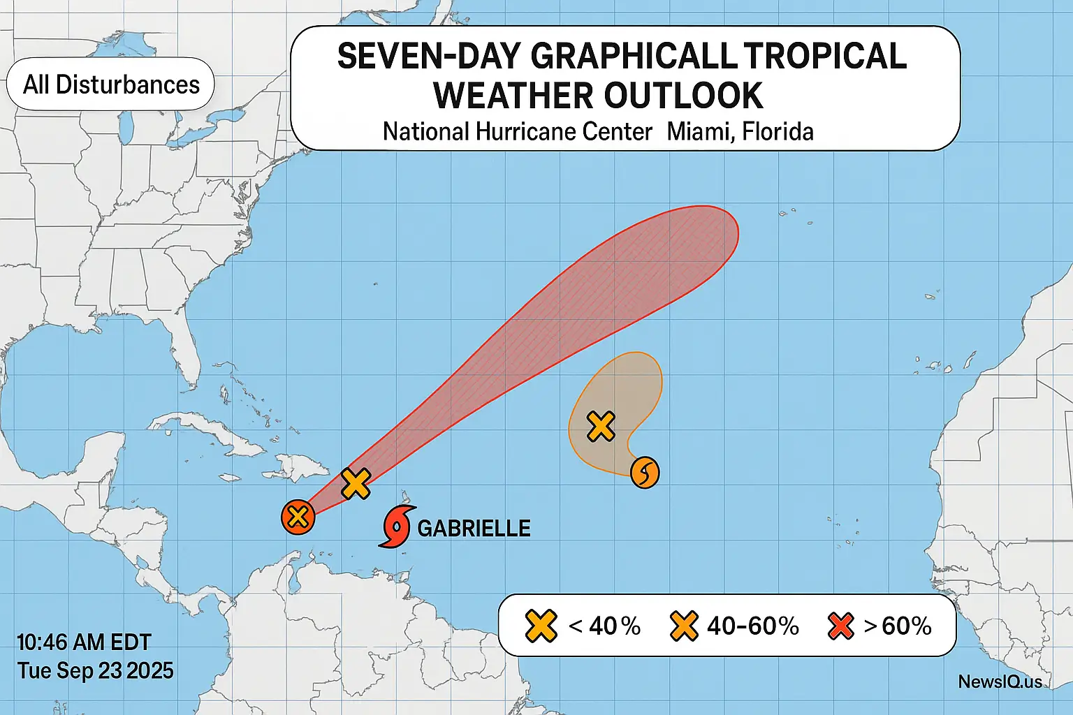
Spaghetti Models: A Visual Portrait of Uncertainty
To grasp the challenge facing forecasters, one need only look at the latest "spaghetti models." These plots, which layer dozens of computer model predictions onto one map, are currently a tangled web of possibilities for Invest 94L.
Some strands send a potent hurricane harmlessly out to sea. Others show a weaker system meandering towards the Caribbean islands, while a terrifying minority paint a picture of a major hurricane impacting the U.S. East Coast. This wide spread underscores the profound uncertainty at play.
| Feature | Tropical Storm Humberto | Invest 94L (Potential Imelda) |
|---|---|---|
| Primary Model Consensus | Recurve into North Atlantic, near Bermuda | Westward track, high uncertainty |
| Development Potential | Strengthening into a hurricane likely | Moderate to High (dependent on interaction) |
| Key Uncertainty Factor | Timing and sharpness of northward turn | Interaction with Humberto and U.S. weather patterns |
| Associated Risks | Bermuda, shipping interests, high surf | Caribbean islands, Bahamas, U.S. East Coast |
East Coast Imperative
The message from every credible expert is unanimous and clear. "Folks on the East Coast from Florida through New England should monitor the progress of these systems," Lanza stressed. This is not a call for panic, but for immediate, sober-minded preparation.
The quiet season thus far has bred complacency, a dangerous mindset when facing the peak weeks of hurricane activity. As global outlets like Al Jazeera often report, the repercussions of a single major storm can have lasting international economic and humanitarian consequences.
What to Do Right Now?
Federal agencies like FEMA and organizations like the Red Cross provide clear, life-saving guidance. It's time to act on it.
- Build Your 'Go-Kit' & Home Stash: Assemble at least three days of supplies you can carry (a Go-Kit) and two weeks of supplies to keep at home. This includes water (one gallon per person per day), non-perishable food, medications, a first-aid kit, flashlights, batteries, and a hand-crank radio.
- Secure Your Documents: Place vital records—insurance policies, passports, birth certificates—in a waterproof container. Back them up digitally to a secure cloud service. Have extra cash on hand, as ATMs may be inoperable.
- Fortify Your Home: Bring in or secure anything that can become a projectile: lawn furniture, grills, trash cans. Clean your gutters to prevent flooding. If you have storm shutters, ensure they are in working order.
- Know Your Zone, Know Your Plan: Determine if you are in an evacuation zone. Have a clear plan of where you will go and how you will get there. Share this plan with family and have an out-of-state contact as a central point of communication.
Developing situation is a fluid, high-stakes meteorological puzzle with millions of lives potentially in the balance. The uncertainty is profound, but the need for vigilance is absolute. As the intricate dance of these Atlantic systems continues, the only certainty is that the next seven to ten days will be critical. The insights gained during this period will determine whether this 'utter mess' dissipates into a memory or coalesces into a historic threat. For cutting-edge revelations and real-time analytical breakdowns, Don’t wait for danger check NewsIQ’s storm alerts now.